February 24, 2022
February 24, 2022
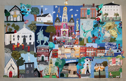
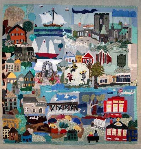
Downtown, 2007-15. Quilt, mixed media. Collection of the Cape Ann Museum, Gloucester, MA. Linen backing made possible through grants from the Massachusetts Cultural Council. Gift of the Art Program at Gloucester's Rose Baker Senior Center, 2015 [Acc. #2015.033.13].

Dear Friends,
It has been wonderful to meet so many visitors and families in the galleries this week as part of the Museum’s School Vacation week programming. If you haven’t yet tried your hand at scrimshaw, please consider joining us in the CAM Studio for this great activity, and this Saturday explore Fitz Henry Lane’s life and artistic career through an interactive, family-friendly discussion in the Museum’s preeminent Lane Galleries (registration recommended).
Today’s issue of CAM Connects is about neighborhoods, eloquently articulated by members of the communities themselves and explored visually thanks to the lens of community quilting. These vivid descriptions and dynamic visualizations of place are evocative of the superb images that so many members of this community shared last fall as part of the Quilted Together exhibition. Your portrait contributions brought the Cape Ann Museum Green campus and the Janet & William Ellery James Center to life, and quilts will again bring us all together this summer at the James Center for the Museum’s first installation of the season in June, featuring the work of Doris Prouty. (More details to follow soon!)
In the interim, there is lots to see and do at CAM, including visiting our new exhibition, Cape Ann Modern, which went on display just this week. A visit to CAM is also a great chance to view Cape Ann & Monhegan Island Vistas: Contrasted New England Art Colonies, extended by popular demand through March 31st.
Looking forward to seeing you at the Museum again soon!
With all best wishes,

Oliver Barker, Director
Introduction
The building blocks of Cape Ann are its neighborhoods, and each one within Manchester, Essex, Rockport, and Gloucester has its own landmarks, traditions, and personality. Just as Herbert Kenny observed in Cape Ann, Cape America, Gloucester’s neighborhoods endow the entire City with “integrity” and a harmony of parts that few other areas can claim.
Today’s issue of CAM Connects builds on the work of the Museum’s 2016 exhibition, Gloucester: A Community of Neighborhoods. Juni Van Dyke, Art Program Director at the Rose Baker Senior Center, reflected on the project, “It began in 2007 as a collaborative art project in celebration of Gloucester—its people—their love of tradition and place. Led by Senior Citizens in the art program at The Rose Baker Senior Center, nearly one hundred participants from every corner of the community enthusiastically contributed their insight and talents to the project. Each quilt is a whimsical portrayal of a particular Gloucester neighborhood, and bears testimony to the joy of belonging and to the truth that the gift of creativity resides within us all.”
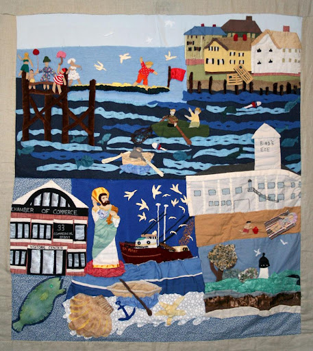
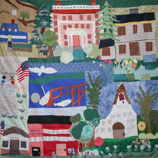
Lanesville and Folly Cove on one side of the Cape; Portuguese Hill, the Fort and Governor’s Hill in the central part of Gloucester; Magnolia and West Parish; Rocky Neck and Bass Rocks. Inspired by this suite of quilts which was donated to the Museum upon completion, below we look at just a few of them and the neighborhoods they represent. To view all of the quilts made during this project, visit the exhibition page, here. ■
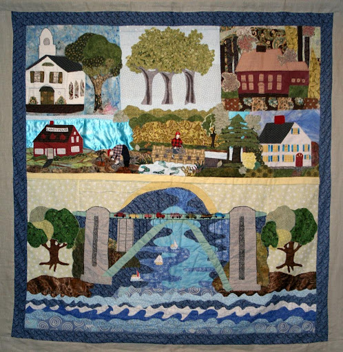
The Fort
The Fort, 2007-15. Quilt, mixed media. Collection of the Cape Ann Museum, Gloucester, MA. Linen backing made possible through grants from the Massachusetts Cultural Council. Gift of the Art Program at Gloucester's Rose Baker Senior Center, 2015 [Acc. #2015.033.10].
By Sal Zerilli
CAM Community Engagement Committee Member
I have been collecting stories about the Fort for over a decade. When I look at the Museum’s Fort quilt, the voices of the people I’ve interviewed and talked to over the years come quickly to mind.
It’s easy to associate the Fort with the Fiesta, as Gloucester without the Fiesta is, as one person I interviewed expressed it, “like a body without a major limb.” It’s also impossible to think about the Fort without thinking about fishing and fish. To outsiders, the neighborhood smells like fish. To insiders, it smells like money.
To some, the Fort is a sanctuary. As an ex-resident put it, "Once I'm in The Fort, I take a deep breath and leave the rest of the world behind me.” To some, the area represents roots. “It’s not Ellis Island,” a young father and Fort resident told me, “but it would almost be like a starting point in the city of Gloucester.” To others, the place exemplifies solidarity: “I’d go into a burning building for The Fort Gang, and I know they’d do the same for me.”
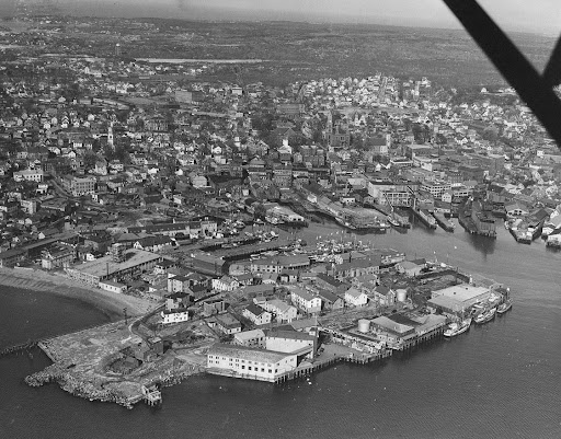
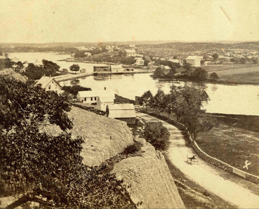
Aerial view of The Fort, Gloucester Harbor, and Downtown Gloucester. Collection of the Cape Ann Museum Library & Archives, Gloucester, MA.
Many of us recall how early generations of Sicilians in the Fort endured prejudice and discrimination. “We were called different things. They called us kinda derogatory names.” We also remember how non-residents feared the place: “People were afraid to come here.” And we hear our friends today talk about the place still being under siege: “Look at the people and forces who are working to destroy it. Ask yourself why they are doing that. Ask yourself 'even if they are not doing it on purpose, why do they not value it?'”
When I saw the Museum’s Fort quilt, I thought about all of these things. But what first popped into my head was the mischief I’d get into down there with my childhood friends, the kind of mischief Joe Palmisano shared recently in one of my favorite Fort stories:
One of the great memories I have of the Fort was The Big Blue Twin Light truck from Rockport. The truck used to make deliveries once a week down the Fort to Bertolino's Bakery, Palmisano's Grocery Store, and Frenchie's Café. In the summertime while playing in the streets, we would see the Twin Light truck come into the Fort stacked with wooden cases of soda in the back. First stop was Bertolino's Bakery, so of course as Fort kids we used to climb up on the truck and hide between the empty cases of soda for a free ride around the Fort. Funny the truck driver never saw us in the back hiding (wink, wink) as he made his deliveries. He waited extra-long at the stop sign at the entrance of Commercial Street to let us jump off. I guess you could say we had an unspoken agreement with the owner Mr. George Sears regarding the greatest rides around the Fort! ■
Riverdale
Riverdale, 2007-15. Quilt, mixed media. Collection of the Cape Ann Museum, Gloucester, MA. Linen backing made possible through grants from the Massachusetts Cultural Council. Gift of the Art Program at Gloucester's Rose Baker Senior Center, 2015 [Acc. #2015.033.05].
Although its boundaries have never been formally set, Gloucester’s Riverdale neighborhood runs from the historic Town Green north around the shores of the Mill River. Dogtown is upland and Wheeler’s Point is to the west. Landmarks in the neighborhood over the years have included a dam built across the upper end of the Mill River; a corn mill which ran off tidal waters that flowed out of a pond created by the dam; Pole’s Hill, a huge granite outcropping at the intersection of what are now Wheeler and Washington Streets; a Methodist meeting house; and the original Town Green. The neighborhood now includes the Cape Ann Museum Green campus and its three historic structures, including the White-Ellery House.
Riverdale, showing Pole’s Hill, Riverdale Mills, and Washington Street c. 1870s. From stereograph published by C.A. Beckford, Gems of American Scenery series. Collection of the Cape Ann Museum Library & Archives, Gloucester, MA.
David Porper, CAM Board Member and lifetime resident of Riverdale, offers his recollections of his neighborhood:
The southern border of Riverdale has usually been considered the northern side of Poplar St. I have lived on the street close to Washington St. for my entire 77 years, which includes a time before the construction of Route 128 and the rotary.
The Radcliffe estate, now the offices of the Gloucester Housing Authority, extended all the way to the marsh. Its northern border was shared with the Babson Dairy Farm which had a barbed wire fence and big barn. The entire housing project now called “Veterans Way” was all part of Babson farmland. You’d hear the cows mooing in the early morning and at dusk. You also heard the fowl crowing in the early morning from Tucker’s Turkey Farm on Cherry Street. It was really like living in the country. The only traffic, save for an occasional passenger car, was from the Department of Public Works which had a new building that still exists today. I remember when a cow escaped the fence and wandered into our backyard and then on to Poplar St. It was quite exciting.
In the Fitz Henry Lane painting that was done from the yellow Babson House looking toward Riverdale, viewers can get a sense of the way the neighborhood looked before my time. The boulder wall that is now on the southern side of Poplar St. was then on the northern side. My house is exactly in front of the wooden gate in the painting. The houses on my stretch of Poplar St. extending to number 18 were built circa 1928 by the Fears Land Co. ■
West Gloucester
West Gloucester, 2007-15. Quilt, mixed media. Collection of the Cape Ann Museum, Gloucester, MA. Linen backing made possible through grants from the Massachusetts Cultural Council. Gift of the Art Program at Gloucester's Rose Baker Senior Center, 2015 [Acc. #2015.033.08]
The four communities that make up Cape Ann are split in half by the Annisquam River and although two bridges – the Blynman and A. Piatt Andrew – join them today, for generations many locals have referenced Gloucester as an island. Route 128, officially known as the Yankee Division Highway, was built between 1936 and 1958 on its current alignment as a bypass route around Boston. It was the first circumferential highway around a major U.S. city and now incorporates sections of I-93 and I-95. The A. Piatt Andrew Bridge is the crowning achievement of the decades-long Route 128 construction project and serves as a gateway to Cape Ann. Residents of West Gloucester, depicted in the quilt above, will be quick to remind you that a significant part of the city lies on the mainland before you take the bridge across the river.
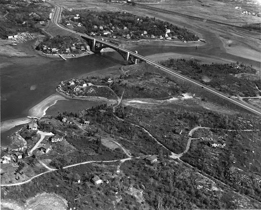
Aerial view of A. Piatt Andrew Bridge, looking north; Wolf Hill at top, Rust Island and West Gloucester at bottom of photograph, c. 1953. Courtesy of the Gloucester City Archives, Gloucester, MA.
As CAM Security & Facilities Manager Nick Tarantino explains:
The A. Piatt Andrew bridge spans the Annisquam River connecting both Gloucester and Rockport to the mainland. As a Gloucester native this bridge and its scenery are imprinted into my consciousness. My mother drove a bus for the Gloucester Bus Company, so I grew up seeing fire-red sunrises and deep purple sunsets. Colorful scenes of the Annisquam River meandering outward to meet the ocean in Gloucester’s inner harbor. The white caps of the buildings at the Heights at Cape Ann, the salt marshes leading towards Wheelers Point and out into the surf of Wingaersheek Beach in West Gloucester. Cape Ann has plenty of landmarks and points of interest that help tell its story, but none as grand in scale as the main entry point to our cities and communities. ■
Portuguese Hill
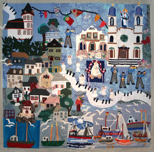
Portuguese Hill, 2007-15. Quilt, mixed media. Collection of the Cape Ann Museum, Gloucester, MA. Linen backing made possible through grants from the Massachusetts Cultural Council. Gift of the Art Program at Gloucester's Rose Baker Senior Center, 2015 [Acc. #2015.033.09]
Overlooking downtown Gloucester and the harbor, the area known as Portuguese Hill is easily located by the stately façade of Our Lady of Good Voyage Church on Prospect Street. The subject of many artists’ compositions over the years, the landmark also figures prominently in the quilt completed by The Rose Baker Senior Center in 2015 under the direction of Juni Van Dyke. The church stands as a representation of the cultural history of the neighborhood and was built as a response to the large population of Portuguese immigrants that began settling in the area in the 19th century. Here is a selection from the CAM Video Vault that focuses on this renowned Gloucester neighborhood.
Video still from VL22 – Portuguese Hill: Celebrating Gloucester Neighborhoods. Panel Discussion. Date: 5/1/2010. Collection of the Cape Ann Museum Library & Archives, Gloucester, MA.
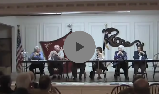
Presented to celebrate the cultural and ethnic heritage of Gloucester’s neighborhoods, this program was held at the Cape Ann Museum in collaboration with the Gloucester Lyceum and Sawyer Free Library to highlight the area known as Portuguese Hill. Six guest panelists representing several multi-generational families of this neighborhood take turns speaking about the churches, commercial endeavors, holiday gatherings, and other activities that created such a close-knit community. This is a lively and entertaining event with many audience members chiming into the conversation as well as to share memories and a laugh about bygone times. ■
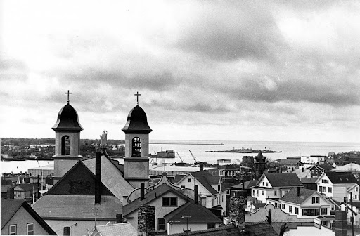
Our Lady of Good Voyage with Gloucester Harbor in background, c. 1950s/60s. Photograph by Gloucester Daily Times. Collection of the Cape Ann Museum Library and Archives, Gloucester, MA. Gift of Barbara Erkkila [Acc. #2001.50].
Magnolia
Magnolia, 2007-15. Quilt, mixed media. Collection of the Cape Ann Museum, Gloucester, MA. Linen backing made possible through grants from the Massachusetts Cultural Council. Gift of the Art Program at Gloucester's Rose Baker Senior Center, 2015 [Acc. #2015.033.3]
By Lisa Ramos
President of the Magnolia Historical Society
How did Magnolia get its name? In the year 1876 the name Kettle Cove was changed to Magnolia in recognition of the wildflower “Magnolia glauca” discovered in 1809. The “Magnolia glauca” is unlike the hybrid Magnolia trees many residents have planted in their yards today. In fact, the flower is a butter yellow color and blooms in early July. The wild Magnolia still grows in this area. It can be found mainly in what is now Ravenswood Park and Magnolia Woods.
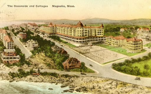
The Oceanside and Cottages, Magnolia, Mass., undated; Postcard. Published by the Albertype Co., Brooklyn, NY. Collection of the Cape Ann Museum Library & Archives, Gloucester, MA.
However, it is still questionable as to how Kettle Cove got its name. Exploration of the history of this village shows Magnolia was called Kettle Cove in the 17th century. There appears to be many theories as to why it was called Kettle Cove. Unfortunately, all documents that may have had the “true” information have not been found at the time of this writing. The legends are as such: Kettle Island was at one time joined to the mainland by a bar of sand and rocks, thus giving the coastline the shape of a kettle. Others say the first settlers, who were given fishing rights by the King of England, came by the name of Kettle and therefore named it after themselves. (Young John Kettle was also granted land in “Macrel Cove,” but nobody knows where it is.) Yet another myth states that at that time stationary fishing nets were called a “kettl’,” so this may be where the name arrived. Still more believe it was purchased from the Indians for a copper kettle. At this point nobody really knows, so you are the judge of how Kettle Cove got its name. Another parable of Kettle Island that has been handed down for generations includes an “Old Granny” witch, a lovely maiden, a dark stranger, and a farmer’s son desperately in love. ■
To learn more about the history of Magnolia, check out Lisa’s book, Magnolia: A Brief History in the CAM Shop.
![]()
![]()
![]()
Unsubscribe | Forward | View in browser
CAPE ANN MUSEUM
27 Pleasant Street, Gloucester, MA 01930
CAPE ANN MUSEUM GREEN
13 Poplar Street, Gloucester, MA 01930
Cape Ann is one of the most important places in the history of American art and industry.
The Cape Ann Museum, thanks to supporters like you, celebrates the history and remarkable contributions of this place to the cultural enhancement of our community and the world at large - yesterday, today and tomorro